
September 23, 2012 - The watchword for today's hike was "variety". This hike had a little bit of everything. Moderate hills, sweeping meadows, a 4-H camp, people's backyards, driveways, wide trails, narrow trails, missing trails (?), as well as paved roads and even wildlife.
I hiked this section of the trail several years ago with the AMC, but it was in the opposite direction. It was lucky I had, because at one point, the directions in the book were poor and the signage non-existent. I lost the trail and had to rely on my memory of where I had hiked all those years ago.
Yesterday was he first day of autumn. Once again the weather was fabulous and, because it's getting cooler, the bugs were at a minimum. It takes over an hour to position my car and I don't get started walking until 1:18pm.
 |
| On the shores of Browning Pond. I'm going to have to bring my kayak here sometime. |
 |
| Betsy helped me position my car, but doesn't have time to hike today. At this point, I'm hiking on the road, so she's hiking too - with the car! |
 |
| Wildlife: a Garter snake suns himself on the trail. |
 |
| I remember hiking in this muck with the Scouts a couple times. Thank you to the Mid-State Trail Committee for these trail improvements. |
 |
| Just as I near the 4-H camp, look who's walking back to meet me. |
 |
|
 |
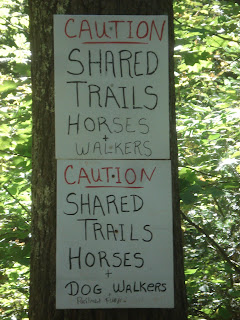
| On the (extensive) 4-H property, I need to share the trail with others. |
| These horse trails were beautiful. So much so, I missed two trail turns because I wasn't watching carefully enough. |
 |
| These young ladies were out for ride. This first horse actually stopped to smile when I got out my camera. |
 |
|
 |
| This is the view from the top of Buck Hill. Umm, yeah. |
| And nearby, the Buck Hill shelter is undergoing renovations. |
 |
| I wondered what the big, black area on the map was - the Spencer Airport. |
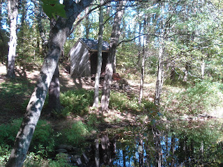 |
| I make it to my second shelter of the day, on the way to Moose Hill. This one is alongside a small pond. It was a good place for a break with a PB&J sandwich. |
 |
| Now, that's a cairn (over 3' tall). |
 |
| The view from the top of Moose Hill - one of the prettiest vistas on the entire trail. |
 |
| Here's where the trail disappeared. Only later did I discover that there was an obscured sign saying "Mid-State Trail over top of dam." |
 |
| This little single-track is actually the trail coming up from the dam onto the road. The next trail sign is still 0.1 miles down the road (very hard to see at that distance). |
 |
| Back at my car on busy Rt 9. Notice the long shadows of late September. |
Now I'm halfway through the town of Spencer, logging 8.2 miles in 3 hours and 15 minutes.


No comments:
Post a Comment