Tuesday, September 25, 2012

Hike 11 - Section #10B & #11


September 23, 2012 - The watchword for today's hike was "variety".  This hike had a little bit of everything.  Moderate hills, sweeping meadows, a 4-H camp, people's backyards, driveways, wide trails, narrow trails, missing trails (?), as well as paved roads and even wildlife.

I hiked this section of the trail several years ago with the AMC, but it was in the opposite direction.  It was lucky I had, because at one point, the directions in the book were poor and the signage non-existent.  I lost the trail and had to rely on my memory of where I had hiked all those years ago. 

Yesterday was he first day of autumn.  Once again the weather was fabulous and, because it's getting cooler, the bugs were at a minimum.  It takes over an hour to position my car and I don't get started walking until 1:18pm.


On the shores of Browning Pond.  I'm going to have to bring my kayak here sometime.
Betsy helped me position my car, but doesn't have time to hike today. At this point, I'm hiking on the road, so she's hiking too - with the car!
Wildlife:  a Garter snake suns himself on the trail.
I remember hiking in this muck with the Scouts a couple times.  Thank you to the Mid-State Trail Committee for these trail improvements.
Just as I near the 4-H camp, look who's walking back to meet me.
  
On the (extensive) 4-H property, I need to share the trail with others.   These horse trails were beautiful.  So much so, I missed two trail turns because I wasn't watching carefully enough.
These young ladies were out for ride. This first horse actually stopped to smile when I got out my camera.
  
This is the view from the top of Buck Hill.  Umm, yeah. And nearby, the Buck Hill shelter is undergoing renovations.
I wondered what the big, black area on the map was - the Spencer Airport.
I make it to my second shelter of the day, on the way to Moose Hill.  This one is alongside a small pond.  It was a good place for a break with a PB&J sandwich.
Now, that's a cairn (over 3' tall).
The view from the top of Moose Hill - one of the prettiest vistas on the entire trail.
Here's where the trail disappeared.  Only later did I discover that there was an obscured sign saying "Mid-State Trail over top of dam."
This little single-track is actually the trail coming up from the dam onto the road.  The next trail sign is still 0.1 miles down the road (very hard to see at that distance).
Back at my car on busy Rt 9.  Notice the long shadows of late September.
Now I'm halfway through the town of Spencer, logging 8.2 miles in 3 hours and 15 minutes.

Sunday, September 16, 2012

Hike 10 - Section #10A


September 16, 2012 - The sky is crystal clear blue today.  It would be a shame to waste it doing chores around the house.  Betsy agrees to join me on my the next segment of my hike, as long as she can keep her part of the hike to around 3 miles.  No problem.  We just have to play some creative games juggling our cars. 

So I start where I left off two weeks ago on Crawford Street in Rutland, while Betsy waits for me where the trail crosses East Hill Road (Alex & I got lost driving around there on the last hike, so I was familiar with the area).  Now that these hikes  are starting further and further away from home, it takes a little more time to get to the start and to position our transportation correctly  Today, I don't actually start hiking until 2:40pm.  With the sun setting a little earlier each day, we wonder just how much time we have to hike.

Across the street from where Alex & I ended last time.  From here, I hike at "Leary-speed" for the first couple miles.
I didn't notice this shelter on the map, but it is in excellent shape with a fire ring in front.
I found this little tenting area next to Long Pond.
I pick up Betsy at East Hill Road.
This is the midway point on the trail:  46 miles to New Hampshire (been there), 46 miles to Rhode Island (yet to come).  Fortunately I have less that 46 miles to cover since we already did some hiking in Sutton (see map).
The trail opened up under the power wires allowing us to admire that azure sky.
This bridge over the boggy area is brand new, of varying widths, and wrapped with chicken wire   We are on the property of Treasure Valley, a Boy Scout camp of the Mohegan Council.
Yes, definitely a scout camp, with works in progress trail-side.
After passing a couple smaller glacial erratics, we finally make it Sampson's Pebble.  A big rock with a lot of graffiti.
Almost back at the car, here's a view of beautiful Browning Pond.
Ooops!  We almost forgot our end of hike photo.  Browning Pond in the background.
Originally, I had planned to hike all the way to the 4-H camp in Spencer, but it was already 4:48, so considering the ride back home, we figured we'd better call it a day.
I was on the trail for 2:18 covering 5.27 miles in Rutland, Oakham, and just the tip of Spencer.

Tuesday, September 4, 2012

Hike 9 - Section #9

According to my original plan, I was not going to hike in August.  Why?  Because it's hot and buggy and there's lots of other things to do in the summer.  Like paddling.  Yes, I spent a lot of time paddling in August.  Betsy & I have already been on some really cool water adventures in Marblehead, Chatham, and Gloucester.  But that's another blog.

So it's Labor Day weekend, and it's time to hit the trail once again.  Alex wanted to name this trip "Let's Hike 5 Miles on the Edge of a Swamp", but I would prefer to call it "Baby's First Hike".  Alex and Cassandra shared the baby carrying duties, and although it wasn't terribly hot, it was still pretty buggy.  In addition, there were some diversions from the trail descriptions in my book (you know, I've got to order a new edition soon).  The hardest part of the this hike was finding the end point to drop the car so as not to make the hike too long.  Once we found the right spot, we took an extreme detour west to Barre thinking it was easier than the way we came.  NOT!  Betsy, Cassandra, and Dominic had to wait nearly an hour for Alex and me to return from dropping the car.

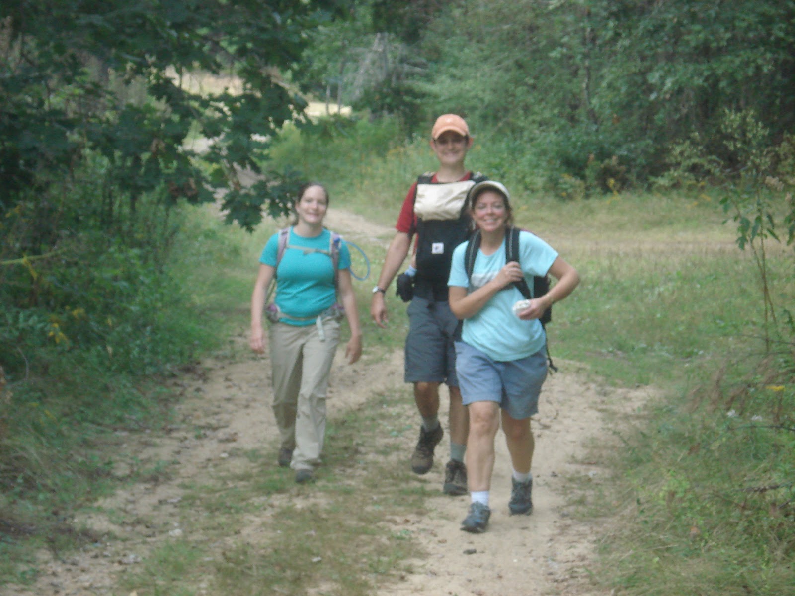
The five of us at a picnic pavilion at the Barre Falls Dam.  The most people on a hike since #1.
An interesting old cemetery just 0.1 miles after we got started.
Taking a quick stop to break out the bug spray.
Betsy was trying to right this marker tree that had fallen across the trail.
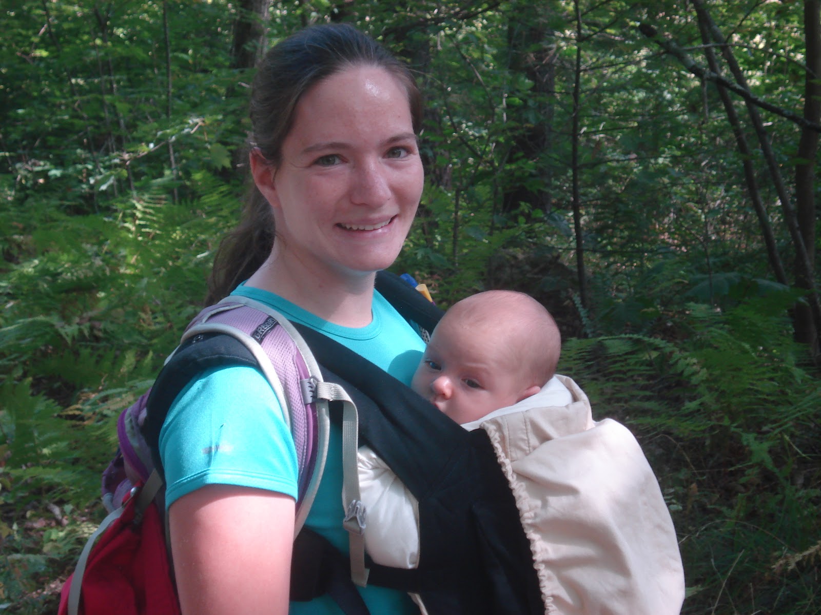
Cassandra and 2-month old Dominic.  He loves his "Ergo" carrier.  But at 11.5 lbs, his days in there are numbered.

These granite benches were in the middle of a small meadow (actually, nowhere).
It looks like it was an Eagle Scout project or Scout memorial of some kind.  Really cool engraving.
This rickety bridge is actually a collection of pallets laid out over a swampy area.  Again, we are nowhere near a road, so it must have been fun hauling them in.
We finally figured out where we were on the map.  I'm standing next to "Dike #3".
The trail opened up to a  wider dirt road.  We are happy to be leaving the swamp.
This bench marks the spot where the Mid-State crosses the Central Mass Rail Trail, an unpaved bike trail traveling east-west.
Alex and I let the women and child rest back at a parking lot for Rutland State Forest.  We hoofed it another 0.6 miles to pick  up the car.  Believe it or not, all five of us will fit in Cassandra's Honda Fit. (har-har).


Because of all the trouble dropping the car at the beginning of the trip, we finished much later than we wanted to (5:18pm), but I'll know better for next time.  The mileage for today was 6.06 miles in 2:46.  There are seven sections of the trail left to hike, so I should make it before the cold weather arrives.