Saturday, August 26, 2017

AMC Paddle - Battleship Cove

It was a picture perfect day for this paddle adventure from Bristol, RI to Battleship Cove in Fall
River, MA.  The water on Mt. Hope bay was unusually placid as 7 hearty paddlers took to their kayaks.


In short order, we pass the  Brayton Point Power Station across the Massachusetts state line.

It's all calm here beneath the I-195 bridge into Fall River.
What's neat about this paddling adventure is you can get really "up close and personal" with the ships in Batttleship Cove.  You can't get these views of the USS Massachusetts by visiting the museum.


Don't you think this gun turret looks curiously similar to the front of a Imperial AT-AT ?

Sort of.  Sorry for the diversion.

The name Massachusetts clearly emblazoned on the  ship's stern.

The USS Lionfish patrolled the waters around Japan back in 1945.

Here's a fine view of the destroyer USS Joseph P. Kennedy, Jr..

Boy our kayaks look small, don't they.

You get a feeling for how the museum ships are tucked under the I-195 bridge.

We stopped for lunch at Bicentennial Park in Fall River.  The park  has it's very own Iwo Jima statue.

On the way back, we heard of the roar of "cigarette boats" racing down the Taunton River into Mt. Hope Bay.
Look carefully for the high water wake.

A ways further, and we made it back to our starting point.  Our trip today covered 11.31 miles in 4:15. 

Friday, August 25, 2017

Cape Recap

This year, as always, we had numerous fun adventures on our Cape Cod vacation.  Since much of the week does not involve just sitting at the beach, I thought it would be fun to quickly recap some of those big adventures.

Saturday

It was a little drizzly Saturday morning, but that didn't deter us in the least.

We stopped by the old  Stony Brook Grist Mill in Brewster.  Today they
were actually grinding corn into meal.  Dominic also learned about weaving
on a loom.
Later, we went miniature golfing.
Catherine is getting the hang it - put the ball in the hole.


Afterward, we went to Mass and had a nice dinner at the condo.

Sunday

Sunshine all day long!  Let's make it a beach day.  We loaded up the boats and set off for the Brewster beach, albeit with a little juggling of cars.
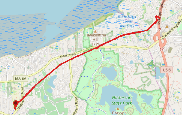
With the high tide, we paddled from Linnell Landing well into the Namskaket Creek Marshes.
You can see how close we got to the bike trail (green line along the bottom of the picture).
The distance was 4.1 miles in 1:30.

Betsy paddles her Calypso easily - there's lot of water at high tide.

Monday

Cassandra didn't get enough paddling yesterday, to at her suggestion, we rented a 4th boat and all of us paddled in the Orleans town Cove.

The Town Cove landing in Orleans is right next to the Goose Hummock kayak store.
We had to be careful in spots as we were short of high tide and there were still some significant shallows.
This distance was an impressive 4.29 miles in 2:09.
The whole family got in on the fun.  Catherine stood almost the entire trip
After that, we made it back to the condo to view the partial solar eclipse through our cereal boxes.

Tuesday

We opted for a different type of adventure Tuesday.  A trip to Martha's Vineyard.
We get up close and personal with animals at the Island Alpaca farm.


Later, Catherine and Grandad go round and round on the
Flying Horses Carousel.


 Wednesday

What would a trip to the Cape be without a bike ride?


Starting at Brewster Bike, we headed down to Chatham along the Cape Cod Rail Trail.
The ride was 17.11 miles for me (4 miles less for everyone else) in 2:06.
Cassandra was able to "draft" Alex hauling the trailer and both kids.
For Alex, it was only an extra 100 lbs.

Thursday

Once again, back on the water, we sailed a Hobie Cat far out into Pleasant Bay.

There wasn't a lot of wind, but with an expert at the helm (our youngest), we were still able to cover a lot of distance.
We sailed 6.83 miles in 2:07.
Easier than paddling!

Friday

Just Betsy and me biking to our last day, so just a short ride.

Leaving again from Brewster Bike, we headed east on the CCRT.
Out and back, this ride was 8.77 miles in 1:14.
Here's a view of the marsh from the bike trail bridge.
Remember back on Monday we paddled within about 50 yards of this position.

So many adventures, so little time.  While we missed our annual visit to The Sands of Time at the National Seashore, there's always next year!

Saturday, July 15, 2017

AMC Paddle - Wickford to Rome Point

This day I had two different paddling adventures to choose from.  I wound up going with the Narragansett AMC since I haven't seen them all season.  As it turned out, I've paddled this route before (see Wickford).  That didn't matter, though, because as you'll see, the pictures I took and the overall experience was quite different.  Last time, I paddled my Cape Horn, a shorter and heavier boat, at a higher rate of speed, making that day much more exhausting than this one.

Today began as a "soft day", as it's known in Ireland - the air and the waters were still while a gentle mist hung in the air.  Because I didn't know if/when it was going to start actually raining, I decided to start with my paddling jacket on, even though when the sun came out later, I might be feeling a bit of heat.

Lined up and ready to go, my Gulfstream is front and center.
You get a real sense of the "soft day" looking down towards the Jamestown bridge.  Look really carefully under the bridge and you'll see he light house that we'll be paddling towards.
Coming out of the marina, we passed this unusual sight. 
Evidently there's no "bull" allowed on the Braveheart.
Ospreys nest on the channel market at the outskirts of the marina.
Here's something you don't see every day. This looked like part sailboat, part pirate ship.
Coming up on the lighthouse and bridge, it looks really close, but there's still some paddling to do.
Here's the Plum Beach Lighthouse up close.  Click on the link to read lots of interesting history about this light and how it was rescued from ruin to its beautiful restoration today.
We've been out over 2 hours, but we still paddle around to the north side of Rome Point, which is part of the John H. Chafee Nature Preserve.  At certain times of the year it's an excellent place for seal watching.
This is why we didn't land on the south side
of Rome Point.  Too many rocks.  Notice
above the rocks there
a distinctive white band of...


... small snail shells - millions and millions of them. 
After lunch, it's back to the boats for the final leg of the journey.
We paddle out of Bissell Cove.  During low tide, we might have to exit the cove the way we came in.  However, with the tide on the high side, we'll be able to paddle around the peninsula and exit at the north end.
We made it back to our put-in sometime later, as most of us returned via the scenic route, hugging the coastline and viewing sites and houses in the nearby town.  In total, we paddled 11.56 miles in 4h31m.  We had a pretty relaxed pace, averaging just over 2.5mph.  Our "soft day" had turned into a mostly sunny and very enjoyable one.

Sunday, June 11, 2017

AMC Paddle: Mystic River, CT

Today's trip was an opportunity to paddle somewhere new.  That said, Mystic, CT itself is not completely new, as Betsy and I have made several visits to this area for early spring getaways.  This adventure, however, would allow me to see Mystic from less typical point of view.  Rather than wandering through the interesting shops and eateries of downtown, I would be seeing it all from the water.  This would include a close encounter with Mystic Seaport, a destination I hadn't visited since Cub Scout days.  There was even a "Sea Music Festival" going on there this weekend, and while our group didn't partake in  any of those activities, we were able to hear sea shanties being sung from shore.  After passing the seaport, the plan was to paddle downriver, circumnavigate Mason's Island. then head back by way of Mystic Harbor.  The Mystic River is a tidal river, so we will be in salt water all day and will have to contend with the water flow of the tides.  High tide was at 10:37am today.

For reference the put in was at  620 River Road, Mystic.  This is actually a great spot right near the highway, but be warned, there are no facilities here.
We get started a little after 8am.  The landing was a pair of small beaches, but with plenty of room to put in.  I was a few minutes late, but that was only because I came the furthest distance and had to stop for gas.
To start, we paddled upriver and explored until we ran out of navigable river. 
We had 9 people in 9 kayaks today.
Here is the new exhibit hall at Mystic Seaport.  The exterior of the building is intended to look like a wave, while the inside resembles the interior of a ship.

   
This is a viking ship that sailed all the way from Norway. Notice the detail woodwork.
This is the training ship Joseph Conrad.
The Charles W. Morgan is the last wooden whaleship in the world.  And it is impressive even with only a couple sails unfurled.
The name on her stern confirms her home port of New Bedford, MA, a city steeped in whaling heritage.
   
We paddled right up beside her. Meanwhile, on the Joseph Conrad, the deck hand on the yardarm is positioning a large stuffed animal for the "Dead Horse Ceremony".


Looking back, the sea port from the water is quite impressive.  Still, the shipbuilding part of the museum continues down along the river for quite a ways.
The seaport even has its own lighthouse.
Here's the railroad bridge that runs over the Mystic River.  Just a couple minutes before I took this picture, the Amtrak Northeast Regional train crossed it.
After that, the bridge swings from the center to allow boat traffic to pass.
While kayaks would have no trouble skirting under the bridge, larger vessels require more clearance.
Click on the video below to see it in action
Click on the video above to see it in action

After over two hours of paddling, it was time to take a break.  We obtained prior permission and stopped at the Mason's Island Yacht Club.  (My Gulfstream is closest in the photo).

Back on the water, we had a great view of the chapel at an Ednumdite retreat center on Enders Island.  The sea wall on the south side of the island sustained substantial damage during Super Storm Sandy back in 2012.  As we rounded the corner, we could see the areas of the wall that require restoration. 
(FYI, Betsy and I were hiking during part of that storm.)
Next, we head around the entirety of Manson's Island, under the train bridge, and back into downtown Mystic.  Here is the famous Rt 1 Mystic River Bridge with it's giant counter weights hanging in the air.
Finally, we pass our favorite restaurant in Mystic, the S&P Oyster Company.
From there is was another mile and half back to our put in by I-95. Our stats were:  11.44 miles in 5:05 with an average speed of 2.24 mph.  This was a very enjoyable excursion and I look forward to joining my Connecticut friends again soon.