Saturday, September 12, 2020

AMC Paddle - Sakonet River

Here's a paddle I would love to do sometime when interstate travel restrictions become relaxed.

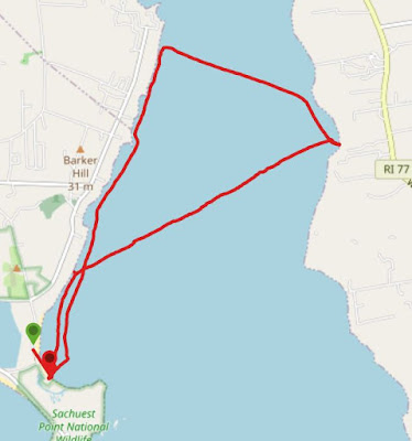
On a Saturday morning, I would head down to the Sakonet River in Rhode Island.  The trip would start in Middletown and cross the river to Little Compton.  This body of water is a river in name only, because it is much more open water sea kayaking.  We need a good leader for this trip, someone who I enjoy paddling with from the AMC Narragansett Chapter.  I'll just have to make sure I get to the Third Beach parking lot at the end of the road.  Hopefully it will be a beautiful blue sky day.


We might not have calm seas with winds upwards of 15kts.

But there might be some cool rock formations right along the shore line.

After almost 2.5hrs and paddling all the way across the river (2.4mi), we should take a lunch break. 

Hopefully the beach has some sand and isn't all rocks.


I'm betting they'll be some impressive houses with stunning views of the river along the banks.

It's even possible we'll run into some "red tide" as we labor through the waves back to our put in.

Taking a straight-line across the river on the way back will only be a distance of 1.75 miles.  It would be a pleasant surprise if the waters calm down a little, but tiring when the wind picks up again.  I would expect the total distance for a trip like this to be about 8.15 miles being done in 4:18.  The company will make it a very enjoyable adventure.

Well, maybe someday. 


Thursday, September 10, 2020

Salem Neck

Labor Day Weekend!  The plan?  Visit Tom & Kay in Marblehead and head out for another paddling adventure.

As for a paddling plan, my very trusting wife and friends left it to me.  We start by departing from Stramski's Beach, the furthest point of the last trip we did back in July.  From there I have a rough idea of where to go based on a trip in my my AMC Sea Kayaking Coastal Massachusetts book.  There are still lots of trips in this book I've never done.  This particular one has trips of 3.2, 6.0, and 12.0 miles although the primary put in is a different location from our starting point. 

My goal is to do some exploring of new shorelines and not "kill" my partners in the process.

We start out at about 10:30am.  The skies are a crystal clear deep blue.
First objective:  head for the lighthouse on the other side of Salem Harbor.


His and Hers Kayaks, right?

We're having a pretty easy time on the way out.  You can see how smooth the water is.


We round Salem Neck into Beverly Harbor and start heading west (even though it feels like south).  Like Dorchester Bay, we see a National Grid gas tank in the distance.  Closer to us is a ziggurat-shaped channel marker.  These were several of these unique structures in this harbor.


About an hour and a half into the trip, we are a little overdue for a break.  We pull up on Sandy Point Beach in Beverly next to the Jubilee Yacht Club.  We've gone 2.8 miles to this point.

Kay and I pass by a lobster boat pulling up traps.  Yeah, we're getting hungry, too. 
Notice how much choppier the water has become.


This gaff-rigged sailing vessel cruised past us in Salem Harbor.
Look at the flags to get a sense of how the wind has picked up, too.
At least the tide is coming in, so we're not fighting that.


We finally return to our starting point after 2:44 and a grand total of 5.21 miles.  That last hour was a bit tiring as we had to fight some of the wind and waves around Salem Neck.  We cross back over to the Marblehead side of the harbor to try to get out of some of the wind and then relax pulling into the beach.  A lunchtime lobster roll is waiting for me somewhere.

It was the longest paddle so far for our coastal-town friends, and I did succeed in not "killing" anyone.  Kay characterized it as a "good workout", but it's fair to say we all needed some recovery time on Tuesday.

Sunday, August 23, 2020

Cape Vacation Adventures

Every year for week #33, we go to Cape  Cod to enjoy a week of family vacation.  But in true "Steve Tradition", this week is not without adventures.  After all, it's The Cape, and there are plenty of opportunities for those adventures.

Sunday, August 16
Nauset Marsh Trail, Eastham

The original plan for the day was taking a motor boat out in Pleasant Bay.  However, the weather had different plans.  The skies looked stormy and the winds were whipping up the waters on the bay pretty fiercely, so our excursion was cancelled.  

As an alternative, we hopped in the car and set off on a short 1.3 mile hike starting from the Cape Cod National Seashore Eastham Visitor Center.  While the building itself was closed, the surrounding trails were wide open.

A map at the beginning will get us on the right track.

Never quite figured out what this was floating in Salt Pond.

The marsh leaves islands at high tide...
... then empties out toward the barrier sand island that is Nauset Beach.

There are small creatures to discover at the waters' edge.

It's an easy hiking trail so everyone can get in on the fun.  The pitch pine & hemlock are on all sides.

Monday, August 17
Cape Cod Rail Trail (East), Dennis & Yarmouth

There is continuing improvement of the Cape Cod Rail Trail.  A couple years ago, it was extended
to the east from its starting location in Dennis on Rt. 134.  Now there's a bridge that crosses the highway as well as another bridge that crosses the Bass River about a mile beyond that.  The was time to explore the new section.

Unload the bikes, load up the chariot, leave the boats behind.
Betsy took a walk down to the Bass River Bridge and we met her there.


A deck on the east side affords a great view of the Bass River. The Mid Cape Highway (Rt 6) can be seen to the north.

The new section of the trail connects to an older section which bisects a public golf course in Yarmouth.

This the the current end of the bike trail at Station Avenue.  Miles from Dennis are marked as "negative" miles.


Everyone's enjoying the ride.  Back to the start, our total distance was 11.86 miles.  I sprinted ahead on the way back and continued into Harwich for another 2.5 miles, but didn't make it all the way to the Old Colony rotary.  In all, I covered 17.4 miles.  Fun day!


Tuesday August 18
To Namskaket Creek, Brewster & Orleans

Later that day, we took the boats out at Linnell Landing in Brewster.  Betsy, Cassandra, Catherine, and I paddled into the marsh.  I forgot to track our route, but suffice it to say it was very similar to the one we did 3 years ago and was probably about 4-5 miles in length.

Alex takes Monica for a ride, too.

Friday, July 31, 2020

Meetup - Lake Quinsigamond

I have been waiting to see a post for paddling on the AMC website, but alas, they have been few and far between.  So, since I make contributions to the Worcester Paddler's Meetup group, I decided to see if there was any action there.  I found an activity on a body of water I have never been on before - Lake Quinsigamond in Shrewsbury & Worcester.  I signed up, but originally I was wait-listed.  However, later in the week I checked my various email folders to find out, that I was now "on" the trip - a Friday afternoon excursion from 4-6pm.  Perfect!

We started way south on lake, south of Rt 20 as a matter of fact.  I didn't even know it extended this far south.  But at this point we're on Oak Island.  It is in the town of Shrewsbury and it is quite populated.

There's a leader and 2 other paddlers launching from this wide boat ramp.  The parking lot also had ample space.
Looking to the east there's lots of lake, power lines and puffy clouds.


Here's our first bridge, passing under Rt 20.
This is a "private" island and it's posted as such,  There is at least picnic table.  Apparently, it can be used if you know the right people.

One of the homes in this compound is owned by Lt. Governor Karen Polito.  Reportedly her mother and brother own the other homes.  The bridge on the right leads from the compound to another private island.  We took a break on a small beach on the Worcester side of the lake.

On the way back, we catch a glimpse of a bald eagle family high up in the trees.

Looping around Oak Island, the lake gets narrow, obscured with lily pads.  And we pass under a very narrow bridge.

We come around the corner and I'm all turned around.  I almost blew right past the put-in site.  But there it is.

This was a leisurely paddle.  We traveled 3.87 miles in 1:40.  What surprised me the most was how long this lake was.  From the northernmost point of our journey, we were still 0.9 miles from Rt 9 where the White City shopping district is.  Moreover, the part of the lake with which I'm most familiar up to I-290 is another 1.3 miles beyond that.  I'll be heading back sometime to do more paddling there for sure.


Sunday, July 26, 2020

Into Salem Sound

It was a very, very hot day and I had an itch to go paddling.  Betsy was busy with the first day of her 9 day virtual music teaching institute, so either I solo or find someone else to go with.  As providence would have it, Tom & Kay were also thinking about paddling today, so it's off to Marblehead I go.

Since we only decided this at noon time, by the time I load up and head to the North Shore, it's 2:20pm before we put in.

We start our adventure at Gas House Beach in Marblehead.  Since a few weeks ago we paddled in Marblehead Harbor then east around Marblehead Neck, this week we decide to head west. The route will take us around Peach's Point and then into Salem Sound.  On the way back, we decide to detour by way of Crownshield Island (also known as Brown's Island) before returning to our put in.
We navigate the choppy waters around Peach's Point and view the new Salem power plant in the distance.

The waters in the sound are much calmer.  Beyond Tom & Kay is the town of Marblehead

At almost 2 1/2 miles out, it's time to take a little stretch break.

This is the pier at Stranski's beach.
The water is warm and Tom decides a quick dip is in order.


Betsy isn't with us today, but I took this picture for her.  This boat is for sale (that means no paddling).  Just call the US Virgin Islands phone number on the sign.  If you can't see it, the home port on the back of the boat says "St. Thomas".  Sounds good to me.

The tide is still low as we skirt the near side of Crownsheild Island.  There's not enough water to paddle so we have to do a little portaging.

Just a few more stokes and we're home.
On our adventure today we traveled 5.28 miles in 2:46.   After an enjoyable dinner, I didn't get home until after 9pm.  It was dark, but I still had to clean my boat and gear from the salt water.

I can't wait to get out again with our friends and do some more exploration of Salem Sound.  My kayak books have plenty of potential routes, but I think we'll do fine just taking it a piece at a time.

Thursday, July 9, 2020

Troop 11 - Bruce Freeman Rail Trail

With bike rides, I only occasionally will add a blog entry.  But with a new trail I will make an exception. 
Today, the plan is for Troop 11 to do 15 miles on the Bruce Freeman Rail Trail in Acton.  Well, we're going to start into Acton and ride up into Chelmsford center and stop for ice cream.  I found the trail description in my Rails-to-Trails book of bike trails in New England.  I printed the map, but little did I know that the trail has actually been expanded quite a bit since the book was published.  The trail extends 3 miles further north than we rode as well as another 2 miles to the south.  There is also a small piece of the trail in Concord and plans to extend beyond that another 21 miles to Framingham.  That will make a nice long, traffic-free rail trail.

In any event we started out at about 5:20pm from NARA Park in Acton.


Six boys and three adults waiting for one more leader to arrive in a fenced off portion of the NARA Park parking lot.

After pedaling 6.9 miles, we stop by the ice cream place whilst trying to find a little shade in the parking lot.  There weren't enough benches and they were in the sun anyway.

The Chelmsford Town Beach is viewable from the trail.  The parking lot was full and beach was very busy as well.

So we're going to have to go a little further to hit 15 miles (one of the requirements for Biking Merit Badge).  So Mr. O says to go down to "the cool bridge that passes over Rt 2A."  I still have dinner to eat this evening, so I take off by myself so I can relay info to those behind me.  We cross Rt. 27 again, but I can't find another obvious place to turn around to keep it at an even 15 miles.  Once I did turn around mid-bridge and headed back to the park, My final mileage was 16.5 miles.  Oh well, just couldn't get that estimation perfect.  My top speed was 23.0 mph, but because I didn't pause the tracker at our 30+ minute rest stop, my "average" came out to 8.6 mph.  Anyway, when I left, all but Mr. O and a couple younger scouts had returned.  It was a brutally hot and humid day, and everyone did well despite the weather.
