Saturday, September 25, 2021

Inner Salem Harbor

It promises to be a very nice  early fall day. September is often an idea time for paddling since the waters are still warn, not yet having chilled down for the season. With that in mind, we head to Marblehead to join our good friends Tom & Kay for an afternoon adventure.

Deciding to make it a more casual day, we opt to NOT attempt a paddle out to the Misery Islands from Manchester-by-the-Sea, but instead to just stay close to home and launch from Marblehead's Stramski Beach into Salem Harbor.  On a previous trip, we paddled around Salem Neck into Beverly Harbor, but today we have a high tide, so it's an ideal time to head to the south end.  


Tom & Kay ask, "Why are you still on the beach, Steve?  Let's go!"

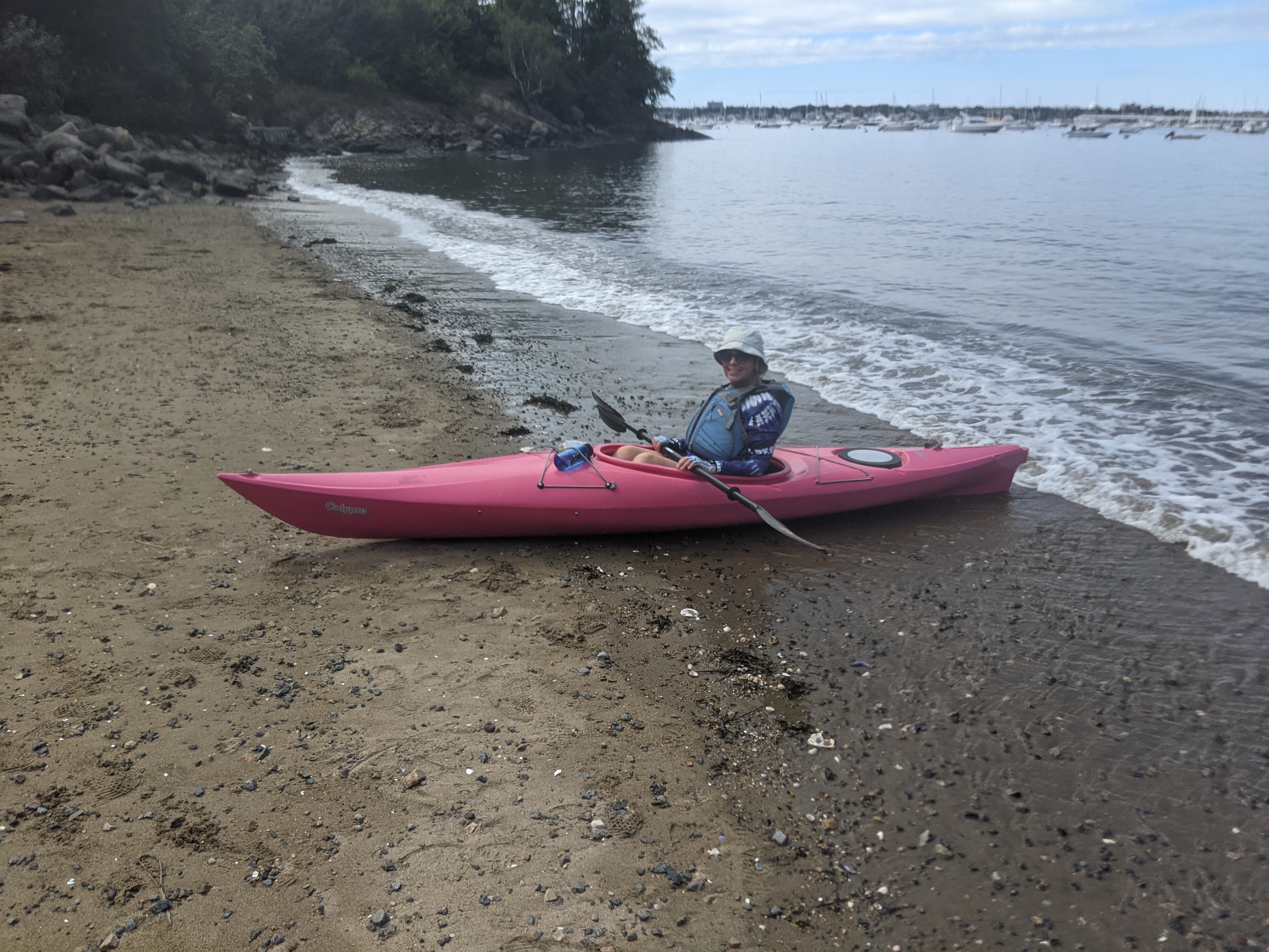
"First things first," I reply.  "My darling wife requests a little push into the water."

We make it all the way to the south end of the harbor.  These rock formations don't always appear this way, because at low tide, this whole area is just mud flats.

The ladies would like to save a little energy to paddle back, so while they head back to the beach, the "mighty paddling guys" go exploring the far side of the harbor.

As we approached this lighthouse, I had the strangest feeling that I had been here before. 
It turns out there are more than one of these styles of lighthouses on the western shore of Salem Harbor.

We headed around one of the wharfs and came upon this tourist attraction.
The ship is called the Friendship of Salem.  It is a reconstruction rather than an original ship. 
It's masts appear short, but that's because the upper halves of them were taken down and are laying nearby on the ground. 


At a nearby "historic" building, there was a wedding party getting some photos taken, although I had a bit of a hard time "capturing the moment" as you can see.  
In any event, I was enjoying my time on the water.

Since Tom & I took a long detour, from the Friendship we decided to head straight back to our put-in expecting to find the ladies waiting for us.  As we approached, however, they were nowhere to be found.  We doubled back along the most likely path to look for them.  

We finally found them employing the "let's let the tide carry us back" technique.  
No paddling required.


Tom & I headed back to the beach to await their ultimate arrival.  
Any time now...

It turns out a little paddling is needed to get back to the beach, after all.

For Tom & I, this was a 2:10 excursion covering 5.21 miles.  I think I can now officially check all of Salem Harbor off as "done".

Sunday, August 29, 2021

Leominster Downtown Sounds

This blog entry highlights a different type of "adventure" for me.  I had a chance to play a "gig" right here in my hometown.  The business development office for the city of Leominster has been sponsoring "Downtown Sounds" in August and September.  Basically, live music in the city's newest park across from the Monument Square downtown.  I signed up to perform and  was there Saturday night from 5pm for 3 hours.  Sorry if you missed it.

Despite a couple rain shower interruptions, it was a fun experience playing and singing for diners, drivers, and passers-by.

Hey, I also have a new website for this sideline career:  https://spfiedler.wixsite.com/music.


Monday, August 9, 2021

White Sulphur Springs Hike

Heading out to Western Pennsylvania is truly an adventure.  We were out here to attend the wedding of my nephew Ben and his fiancĂ© Madison.  The wedding and reception was located  a White Sulphur Springs, a Christian retreat center catering to military officers and their families.  Nestled between two ridges, there are over 1000 acres of fields, ponds, trails, and more.  Suffice it to say, leaving your cell phone behind is probably fine, as the service availability is pretty poor.


It's early, but since we're on "military time", we decide to get out for an early morning walk.  It's cool, but, there's a lot of humidity still lingering in the air.  A t-shirt and shorts will be fine.  Moreover, the bells for breakfast start going off at 8:15, so we'd better get a move on.


Even though we have a map, we wind up loosing the trail along the way (see far right of our track).  Fortunately, the Scripture quotes on signage in the woods get us back on track.

Whew! We found our way back.

The sun comes up later than in New England, so the mist in the valleys will linger.

On this enjoyable 45 minute walk, we covered 1.81 miles and 306' of elevation gain.  After shower and breakfast, it's off to our day at Indian Lake with Cassandra and the family.


Saturday, August 7, 2021

Hawk Mountain Sanctuary

On the way to my nephew's wedding western Pennsylvania, we stopped over for a couple days in Bethlehem  With extra time on my hands, I decided to explore a hiking property I've heard a lot about but never had an opportunity to visit:  Hawk Mountain Sanctuary in Berks County.

The sanctuary is maintained by an organization that promotes raptor conservation science and education.  It is apparently a school field-trip destination for districts in neighboring counties.  From Bethlehem, it was an easy 45 minute drive west. 

Once there, I discovered that there was a fee to go hiking (which I wasn't expecting), but I figured it was for a worthy cause, so I ponied up the $10.  My first decision was to pick a trail.  Being by myself and since I had the time, I figured 4 to 5 miles would be a good distance goal.  The River of Rocks Trail seems like a good place to start

Wow!  This looks like it will be a nice trail.   Just a little ways down and already a great view.
Hazy, yes.  And I have my "paid" sticker on, too.


Some kids are enjoying the vista, but in another way.

One of the features along this trail are two boulder fields, as shown here.  It is a low point where the glacial "leftovers" were deposted.

While this trail was mostly downhill, it was more difficult than I anticipated. 
When I read "River of Rock", I was thinking a river (or river bed) with a few rocks in it.  It turns out,
 I was hiking on a trail of rocks.  I might not have taken it if the trail was named such.  Exhausting!

I made to a trail junction where I see a sign informing me that indeed, this was a DIFFICULT trail.
Well, perhaps the worst is behind me.

I get to the next trail junction only to find that I've stumbled onto a double black diamond trail instead.


Can you believe this?  Rocks, rocks, and more rocks.  It is not easy hiking over these, as you always have to make sure your footing is good so you don't get hurt.  And as you can see, there are also some challenging uphill paths to boot..

This is a nice view from the top of the ridge, but still hazy.

I'm sure you're tired of looking at uphill rock scrambles, but maybe it gives you an idea of how I felt.

At this end of the trail, there's an actual fence and places to sit.  Time for a lunch break.

Still a great view from atop the ridge.


So evidently, this was the easier way to the ridge views.  There are stairs to climb instead of bouncing over boulders and even some benches scattered here and there to rest on.


Looking off to the south, I can see the two boulder fields, one of which I saw near the beginning of the hike.

Here's an historical recap. 

I've included this elevation profile to how steeply I descended at the start of my hike, only to climb more steeply immediately afterward.  In any event, the hardest part of the hike was probably the ridgeline anyway, scampering over the abundance of rocks on the path.

I was shooting to hike between 4.5 to 5.5 miles, but the difficulty made the actual 4.13 that I did challenge enough.  As it was, it took me 2:45 with an altitude gain of 1044 feet (that's one "Mt Wachusett" from the ski area base).  Suffice it to say, with the high humidity, I was drenched.  The little yellow sticker fell off my shirt who-knows-where and wasn't there when I was done.


Saturday, July 24, 2021

Bike Ride - East Bay Bike Path

For many years, I have read about what a treasure the East Bay Bike Path is in nearby Rhode Island.  It is a true rail trail, and I have seen it written up numerous time in publications from the Rails to Trails Conservancy, a non-profit I have been a member of since 1997.  I have seen this trail while paddling in Narragansett Bay, but have never had to opportunity ride on it.  Today's my day.

The East Bay Bike Path was built before rail trails became "a thing".  However, for it's age, it is exceptionally well maintained and riding it end to end is an enjoyable and worthwhile experience.  

The trail begins at India Point Park in Providence, the city where Alex and Cassandra attended college.  The question was, exactly where in the park?  It turns our there was not a lot of helpful signage, so  I asked a man walking near one of the parking lots.  His directions were helpful, if not somewhat convoluted, telling me I had to "go over a hill, behind the manufacturing company, then cross that bridge" as he pointed above.  Umm, ok.  So I find a place to park and look for "a hill" and a "manufacturing company".  Finally, I ask another casual biker and his girlfriend if they had any suggestions.  He pointed me in a general direction and I followed.


Ahh!  Here's the entrance to the bike path.  It actually wasn't that easy to find.
A quick switchback up the hill, behind the hotel, then over the Washington Bridge spanning the Sekonk River which also carries traffic on Interstate 195 to the Cape.


Meanwhile, the trail goes
roadside for a little while.
I'm over the bridge and now I'm confused.
The Blackstone River Bikeway is supposed
to connect to this bike path, but to my 
knowledge, it's not yet complete
into Massachusetts.

I remember seeing this industrial area when it paddled up the Woonatocket River into Providence.

This is sort-of a "bay cabana" connected by a causeway to the "big house" out of frame to the right.

I've seen this lighthouse before, but from the water back in 2016.  
It's really beautiful on a sunny day like today.

The bike path winds through 5 towns in it's 14.5 miles:
Providence, East Providence, Barrington, Warren, and Bristol. 
What I didn't realize until the way back was the the mileage accompanying the town abbreviation ("Barr" = Barrington), actually counted DOWN so it told me how far I had to go to get to the end.  

In Bristol, the path runs right along the bay for spectacular views.
The trail ended a little further on at Independence Park.  I rested there for a while and chatted with a guitarist and his wife who were doing an impromptu performance.

The views from the park were great. 
Behind me, you can see plenty of moorings in this protected part of the bay.

I forgot to mention there were two detours off the bike path due to bridges in need of some serious repair.  A fellow biker told me that they've been out a year and a half because "it's Rhode Island". 
This detour took me back into town and over a road bridge.

The broken down bridge is in the background.  At this hour, the tide was going out. 
Even in this still photo, you can get a sense of the rushing water around the bridge supports.

There were a lot of sections of the bike path they resembled sections of the Cape Cod Rail Trail: 
not adjacent to the water, but winding through lush woodlands.

There are multiple parks accessible directly from the bike path.  This is Haines Memorial State Park in Barrington.  At this point of my ride, I needed a little food break, so I stopped for a couple granola bars.  You can see that there's water in the distance a couple hundred meters behind me.

Indeed, this is a great boat launch with ample area to park.  Maybe it'll be a kayak put-in in the future?

Heading back north, one can get a really good view of downtown Providence.

My total distance today was 30.11 miles in a time of 2:55 (including breaks).  Most of the time I was traveling between 12-15 mph.  My tracker also said I did 1111 feet of elevation, but that's a little hard for me to believe.  

If you venture onto this bike path, be aware that it is a very popular place to bike, walk, and roller skate.  Walkers stick to the "left" lane, so you have to be careful not to run them over as you're heading toward them.  Being close to populated areas, I think there are a lot of casual bikers on this trail, as evidenced by majority of people not sporting a bike helmet.  In any event, enjoy!