Saturday, October 17, 2020

Late Season Lobster Roll

 A beautiful Saturday morning   in October.  We're thinking   it's  a great day to get out of   town but where to go?

 Betsy just finished reading a   story in Yankee Magazine's   Summer 2020 issue about a   great place to get a lobster
 roll on the Connecticut   shoreline (see photo left or in Yankee Magazine).


On this excursion today, we extended an invitation my parents so they could get out of the house for a while.  When I told them the plan - lobster roll and maybe a nature hike - they happily joined us.

The magazine photo was so inspiring that we had to make sure to take the same picture with us in it (see photo below).


This place was great.  Only 4 entrees on the menu,
but the warmed lobster was available with a gluten free bun.  

Better make sure you fuel up now.  This is only our first stop.

Stop #2 is Hammonasett Beach State Park, just a short drive away.  
Let's get out the trekking poles for our nature walk.

A short gravel path leads out to through the salt marsh to an overlook platform on the East Beach.

It's one step at a time under a clear azure sky..

When the walking is done, it's time for stop #3.  Let head out to the sandy part of the beach.  
No chairs?  No problem.

Well, somebody had to test the water.  It wasn't cold, but that wave actually soaked my pants.

The response from the onlookers? -  "No thanks - we'll skip the water play."

It's almost 2 hours back home, so we make one more stop (#4).  
This time for ice cream in nearby Madison.

It was after sunset when we arrived home, as the sun is now setting before 6pm.  Although driving to the Connecticut coast for a lobster roll sounds crazy, we all agreed it was well worth the trip.


Monday, October 12, 2020

Columbus Day Hiking

We did sort of a figure 8: first the upper loop, the the lower. 
It feels so good to get outside these days, doesn't it?  To that end, Betsy & I decide that it's time to venture out for a little hike.  Or two.  I have the day off for Columbus day, and with the gray skies it's not much of a beach day, so we decide to head off into the woods instead.  But not too far away.

Once again I opt to peruse though the Trustees Special Places book to find some properties we haven't yet visited..

Our first stop is Elliot Laurel in Phillipston, just west of Templeton and Gardner.  The property is pretty small, but there is promise of some nice wooded trails.
Dressed for the weather... and ready to hit the trails.

These trees look a little like they came out of a fantasy.  
Maybe we're on the edge of the Fire Swamp?

Here's a close up of the view that's behind me.
Even with gray skies, the colors are vibrant.


The forest floor here is covered in ferns that have faded to autumn yellow.
We covered .92mi  and 183ft of elevation here, but we're ready for more.

Heading west, we have our choice of another couple of Trustees properties.  We decide on Brooks Woodland Preserve in Petersham. This property has a much more extensive trail network, but again, no big hills or mountains to climb.

Once again, we have this place to ourselves.  We park on the side of the road and head off the "red" trail to the north.


It's a good thing Betsy's navigating.
Now wait, are we supposed to be on the white trail
or the red trail?


This trail skirts a swampy area.  Across the pond there's a big beaver dam.

Ohhh, no wonder we're confused.  It's white to left and red to the right!

Betsy enjoys the nice wide trail on a carpet of leaves.

On this part of our hike we walked 1.63mi with 195ft of elevation.  The light sprinkles didn't bother us in the least and we still have time for more afternoon adventures.

Sunday, October 4, 2020

Chesterfield Gorge and More

We hike .7 miles each way in
the Chesterfield Gorge & on the East Branch Trail


For several years now, I have been a member of the Trustees of Reservations, a conservation and historical organization here in Massachusetts.  We primarily use this membership for visiting Crane Beach in the summer season, but the Trustees have properties all over the state including Doyle Community Park right here in Leominster.  I figured it was high time we explore  some of the many other properties they have to offer.

On this particular Sunday, we head off out west to find Chesterfield Gorge.  The hook was to "Hike the half-mile trail along the cliff tops and take in wonderful views of the gorge, the river, and the surrounding forest" according to the website.  

The property entrance was on a little backroad.  Don't blink or you'll miss the entrance.  


It will be a "nature walk" today.  The short tail leads away behind us.

The wire fence behind us keeps us away
 from the very steep walls of the gorge. 
Here's a glimpse of the gorge with the
Westfield River below.

Once we leave the "gorge" part of the property, we proceed down the East Branch Trail, which it turns out is actually a jeep road along the river.  The trail has some dips and puddles and can be used by mountain bikers in addition to hikers.  After 8 miles it connects to the Knightsville Dam, passing through the Chester State Wildlife Management Area.  We're not going that far today.

This trail sign has grown right into the tree.


Once we get down the trail a ways, I'm able to jump the rocks out to the middle of the river. 


Betsy is taking my picture from the river bank.

It's a leisurely walk back up the hill to the parking lot.  From there, we walk to the farthest end of the trail to explore other views of the river and gorge.


Looking up river, we can see this old stone wall which appears to be an abutment for a bridge which spanned the gorge at one time.  It has long since washed away, but behind us on the west side of the river there is still evidence of an old cart road depressed onto the landscape.


Next it's on to explore more nature in this part of the state.  Betsy turns on trusty Google Maps which leads us back up the steep hills to what appears to be Chesterfield Common.  I suggest to go north to head back towards Rt 2 (instead of east through Northampton & Amherst), and we are directed via the most direct route - which happens to be a dirt road.  Good thing we're in the Rav4 today.


Emerging from the forest we are heading north on a good road and decide to visit DAR State Forest on our way.  I have actually heard about this place.  It is known for it's beautiful lakeshore and comfortable campground.

It's still early October, so the colors are beautiful, but there's lots more to come.

We take the road back further into the park and find a trail up the fire tower.  While I'm busy scanning the QR code for the trail map, Betsy points 60 meters uphill and says "There it is!".

We left the park after a little while at the fire tower looking for a place go grab a bite, but it's still pretty hard to find places with all the pandemic restrictions.  Maybe we'll have better luck next time.


Saturday, September 26, 2020

AMC Paddle - Rome Point

After my last blog entry, I had several inquires as to other trips "future Steve" might be making.

I thought about maybe another Marblehead trip with our good friends there.  On the other hand, maybe that crew from AMC in Rhode Island would be up for another trip this season.  After all, it would MikeK's 80th birthday this week.  I finally determined that a trip to Rome Point in Narragansett Bay (like the one I did 3 years ago) would be ideal.  But perhaps a trip that could include people of varying abilities, where there would be several paddling options to choose from.

For a start, going in late September would mean that we could launch from the North Kingstown Town Beach (where the bandstand is).  Normally, there would not be enough parking on a busy summer weekend.  A mixed group of experienced and intermediate paddles would enjoy an excursion like this.

September is such a great month to paddle; the water is warmer and the days turn out generally sunny.  Those clouds beyond are not rain clouds, but morning fog.

Since we'll have multiple skill levels on this trip, we do a quick paddle around Fox Island then head to Rome Point for lunch.

Viewing the lunch area from the water, you can get a sense of now narrow this peninsula is (the water is right on the other side).   From here, the group will split up with a) some going back to the put-in, b) some going past the put-in to explore Wickford Harbor, and c) some heading out the
Plum Beach Lighthouse just north of the Jamestown-Verrazano Bridge.


I thought I would photo-shop myself into a picture of paddling on the bay.  I picked photos with no fog.  The first one gives you an example of how tricky taking a photo while paddling can be.

For reference, here's what you'll need to know if you embark on this adventure.  Good luck.

    
8.71 miles
2.12 miles/h
04:06:49

Saturday, September 12, 2020

AMC Paddle - Sakonet River

Here's a paddle I would love to do sometime when interstate travel restrictions become relaxed.

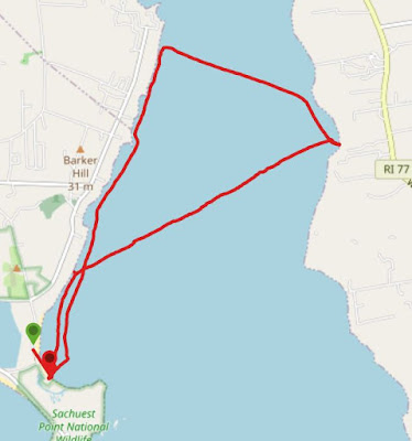
On a Saturday morning, I would head down to the Sakonet River in Rhode Island.  The trip would start in Middletown and cross the river to Little Compton.  This body of water is a river in name only, because it is much more open water sea kayaking.  We need a good leader for this trip, someone who I enjoy paddling with from the AMC Narragansett Chapter.  I'll just have to make sure I get to the Third Beach parking lot at the end of the road.  Hopefully it will be a beautiful blue sky day.


We might not have calm seas with winds upwards of 15kts.

But there might be some cool rock formations right along the shore line.

After almost 2.5hrs and paddling all the way across the river (2.4mi), we should take a lunch break. 

Hopefully the beach has some sand and isn't all rocks.


I'm betting they'll be some impressive houses with stunning views of the river along the banks.

It's even possible we'll run into some "red tide" as we labor through the waves back to our put in.

Taking a straight-line across the river on the way back will only be a distance of 1.75 miles.  It would be a pleasant surprise if the waters calm down a little, but tiring when the wind picks up again.  I would expect the total distance for a trip like this to be about 8.15 miles being done in 4:18.  The company will make it a very enjoyable adventure.

Well, maybe someday.
