Saturday, August 10, 2019

AMC Paddle - Barn Island

I haven't had a chance to paddle with Barry and the AMC Connecticut chapter for a couple years, so I welcomed this opportunity to explore another part of the shoreline of the southeast coast.  As it turned out, this was a two-state excursion. 

Betsy and Peggy came along, not to paddle, but to spend the day in nearby Mystic for shopping and  an arts festival.  The map at right shows a macro view of where we were in Connecticut and Rhode Island.  At the end of the day, the plan was to head over for a meal at the gluten-free friendly S&P Oyster Restaurant.

It looks like it's going to be a great day to paddle.  The sky is a brilliant blue with just a few puffy clouds.  The temps are a lot more comfortable than last week, but it's a bit breezier, too.  We'll see if the wind becomes a factor later in the day.

We put in just a little after 10am.  Barn Island is an actual island off the Connecticut coast, but we are just launching from there;  there's no circumnavigation this time.  The water's fairly calm but we're heading right into the wind.
We go right around Stonington Boro, which juts way out into the surrounding harbor.
Around the point in the east side of the boro, we regroup to get a plan for the next couple segments of our voyage. 
Notice the water is getting a bit choppier.
As we take off again, I notice this lone tree sprouting out of what appears to be heavy-duty rock at the end of a nearby peninsula.


What do you think of this property?  Notice the stiffness of the flag flying in front.
Our next objective is short breakwater.
We will paddle on the lee side of this breakwater, as the wind and waves are coming at us pretty strongly from the southwest.  You can see the channel marker at the far end.  When we get there, the water is really choppy, so there's no more time for me to safely take photos.  When we pass by that channel marker, it's a LONG 0.5 miles to the next breakwater.

Just to give a little perspective on where we are,
After we round the corner of the second breakwater, it's about a mile out toward Napatree Point,
which is actually in Rhode Island.   Note, we actually circumnavigate Sandy Point, but never actually stop on it.
We're pretty tired by now, and we take our scheduled lunch break.
After lunch, we head easterly toward Watch Hill, Rhode Island.
We paddle through the marina and catch sight of Ocean House, a 5-star hotel overlooking the harbor.
In the foreground of this picture, you'll notice that we still have quite a bit of chop on the surface of the water.
After that, no more photos.  We've been fighting the wind and waves pretty much all day, and everyone's getting tuckered out.  We still have a ways to go to finish our trip, so we focused on that.
All told, we paddled 10.17 miles miles in 4:29.  The wind was probably close to 15 knots for most of the trip and being in open water didn't make it any easier.   It was definitely one of the toughest paddling trips I've ever embarked on.  But we all made it safe and sound and no one went in the water.  Oh, and dinner in Mystic was delicious.

Saturday, August 3, 2019

AMC Paddle - Peddocks Island

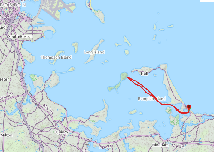
When I saw this trip come up, I signed up right away.  The plan was to visit another one islands of Boston Harbor Islands National and State Parks, a place I'd never been before.  The map at right shows more clearly a little more context of the area that we paddled in.  Our destination today is Peddocks Island.

Our put-in is in the town of Hull , which juts out into Boston Harbor in the same way that Cape Code does into Massachusetts Bay.  It actually takes quite a while to to there from central Massachusetts (1:35) because it is NOT located off any  major highway.  Once there, it feels very seaside and far away.

Our put-in is right across from the Paragon Carousel on Nantasket Beach.  We have 9 paddlers today
We paddle up the Weir River a ways up to Sunset Point.  One of the residences at the end has many beautiful floor to ceiling windows overlooking the harbor.
We finally arrive at our lunch stop on Peddocks Island.
There are Adirondack  chairs waiting for us along the beach.  Behind it are some of the old buildings that were once part of Fort Andrews.  The only building open is the one on the right, which was the old administration building.  The island is staffed by Massachusetts State Park rangers, not National Park Service ones, and this building has some small exhibits and activity space.  The other building on the left is used for maintenance.  Most of the other buildings on the island are in disrepair.


However, this church (opposite the administration building) can still be rented out for weddings on the island.  The island actually extends quite far to the southwest behind the church.  There are trails to make your way all the way down there, but we only explored a little area around our landing.
Here's the island dock.  Water shuttles run most of the day between Boston, Hingham, and several of the harbor islands.
Most of our group ate lunch along the beach, but I headed over to the other side of the buildings.

From there I had a great view of the Hull Gut, a narrow waterway between Hull and Peddocks Island with a fast current.  On the Hull side, you can see an active windmill.
We paddled back roughly on the same path we traveled out.  We considered skirting Bumpkin Island to the west, but the wind and seas dictated we take the lee side.  On today's trip we covered 8.97 miles in 4:41.  The weather stayed partly cloudy most of the day and everyone did well.  Finally, just before we got back to the put-in, we passed a residence where the partiers  in the backyard were being serenaded by an Elvis impersonator; well, of course it was an impersonator - they couldn't afford a real Elvis.  Memorable to be sure.

Wednesday, July 24, 2019

AMC Paddle - Circumnavigation of Newcastle Island

Wow!  Is it hot!  Yes, it's the hottest day of the year.  Temps are supposed to top out around 99 degrees with "real feel" between 105-110.  All this on the 50th anniversary of the Apollo 11 moon landing.

What's a paddler to do to stay cool/  Why, get out on the open water, of course.  Today's adventure is in the harbor of Portsmouth, New Hampshire.  The trip leader, Jerry, sold me my Gulfstream, the boat I am taking out today, 3 years ago.  He said he missed that boat, but unfortunately I told him he's not getting it back.  :)


We meet for our trip at 12:00N, relatively late, but is planned that way so we won't be fighting the tides all day.  The traffic on I-95 through Salisbury and Hampton is horrible.  Why does everybody keep stopping?  On the trip, there are 9 of us and we actually don't get underway until 12:45pm.

It's so hot and the flies are biting, so the best thing to stay cool before we depart is to wade into the water.
We had to cross multiple busy channels today. 
The traffic consists of recreational as well as commercial vessels such as this fishing boat.
We make a stop at Wood Island, home to an historic life saving station.
This quiet little cove was just a "stretch your legs" break.  There were great views in all directions.
To the east, Whaleback Light stands at the entrance to the harbor.
Back under way again, we're careful to stay clear of these rocks, in addition to the ones just below the high tide line.

As we start heading further into the harbor, we pass another lighthouse, Portsmouth Harbor Light
Old Fort Atkinson still stands next to the lighthouse..

A little further on, we pass large castle like structure which is actually  the derelict Portsmouth Naval Prison, which still stands on the grounds of the Portsmouth Naval Shipyard. 
Interestingly, the shipyard is actually on the Kittery, ME side of the harbor.

We take a lunch break on Pierce Island (actually Four Tree Island) in Prescott Park.  This was a really nice place for lunch with picnic table pavilions, restrooms, and running water.  The views up river were also terrific.  

After lunch, we snaked our way down the west side of the island, passing under a couple bridges on the way back to the put-in.  For a super-hot day, this was definitely the place to be.  We covered 8.42 miles in 3:49 and we were off the water by about 4:30pm.  The afternoon traffic was much lighter than that in the morning.  Stay cool!

Sunday, June 23, 2019

Denali National Park

It's the second Sunday morning of our Alaska vacation and we wake up in our lodge just outside Denali National Park.  The tour itinerary says that after breakfast, we are off to "Glitter Gulch", a stretch of shops across the street from the Princess complex just outside the park.  However, Betsy, Tom, Kay, and I would rather go see the National Park Service sled dog demonstration and then visit the  park Visitor Center to take in the exhibits.  If time permits, we would like to actually get a short hike in.  The only time deadline we have is to make it to the train station by 3:15 to catch our transportation to Fairbanks.  So off we go.

After touring the Visitor Center, I check out the trail options outside the rear entrance.  It looks like we have time to take the Taiga Trail and Horseshoe Lake Trail  and still make it back in time.  (As it turns out my calculations were off by a bit, so we would have to keep moving on our walk.)


To begin, the trail winds between towering spruce trees.  As everywhere else in Alaska, the flowers are beautiful.

We cross the main road of the park that leads to the tundra and the fantastic scenery surrounding Mt. Denali. 
Yesterday, our bus tour took us this way.
The trail has  boardwalks where needed to keep us out of the boggy soil.  By the way,  Taiga is defined as the sometimes swampy coniferous forest of high northern latitudes, Yup, that's it alright.

We cross the tracks on foot now, but later we'll be on board the train.
Our first view of Horseshoe Lake.
Betsy's Del Sol t-shirt changes color in the sun.

This is a lot of steps to go down, but the challenge will be when we have to head back this way later.
The colors in the forest are just spectacular.

Betsy spotted a little beaver swimming near this substantial dam.
"Glitter Gulch" is in the background, but we are happier to be here at the lake.


This narrow trail on the far side allows us circle the lake.


From this very sturdy pedestrian bridge, you can hear (but barely see) the river far below.


A little longer and we're back on the Taiga Trail to the Visitor Center.  Today we've hiked 4.1 miles and over 300 feet of elevation at a very respectable 2.1 mph (we are sight-seeing, too, after all).  And yes, we made it back in plenty of time for the the train.

Saturday, June 1, 2019

AMC Paddle - Nashua Still River in Spring

The Nashua River is so nice and close my house that it is a pleasure to do this paddling adventure any time of year.

As in the past, Jeff is leading us down and then back up the river.  We start at Still River Depot in Harvard.  The parking is adequate, albeit not enough where we need it.  The boat ramp into the river is concrete, but steep.  Being a more experienced paddler, I help many of the others get into their boats without tipping over.  We have 12 participants in 12 kayaks (no canoes today).  We put in at about 10:10am. 

Downstream to start.  Lots of boats in the water.  Current less than 1mph.
I've passed this wall-like feature several times and have yet to figure out what it is.  It's on the Devens property to our west.
We lunch up the hill at the amphitheater at the Bill Ashe Visitors Center.
Going back upstream, some of the water was so still, that the reflections were fantastic.
This trip was an excellent for novices, but I enjoyed it very much, too.  We were out for 4:24 and covered a distance of 8.73 miles.  One of the best parts for me was only 15 minutes to get home.  This is one of the few river stretches that I do that it is actually reasonably easy to paddle back upstream to your starting point.  Have fun out there!