Saturday, April 28, 2018

AMC Paddle - Contoocook River Peterborough

Finally, it's spring.  Well, almost.  Although paddling season can begin as early as March, winter hung on for a long time this year.  Moreover, the activities schedule has been jam packed not leaving a lot of time for outdoor adventures.  But finally at April's end, the clouds and the schedule cleared for long enough to get out on the river.

This day we're traveling on the Contoocook River up in Peterborough, NH.  The temperatures are in the 50's with a mostly cloudy sky (warmer than back in December, for sure).  We met a the Eastern Mountain Sports headquarters store before dropping the boats and shuttling the cars. DaveM again led a fairly large group:  9 kayaks, 5 canoes, and 18 participants.  We had some recent rains and were expecting the current to be fairly fast.  But no one knew what kind of obstacles we would face on the river.

We put in a bit late at 11:31am.
Lots of boats including 2 yellow Pungo kayaks (down front):  mine at 12' and the other at 10'.

Just beyond this bridge on US 202  is a dam and beyond that the town of Peterborough.

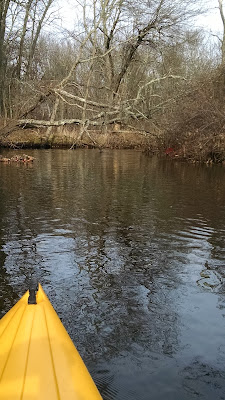
The current is helping propel us down the river quickly, sometimes necessitating us to pull over and wait.


After navigating under a particularly tricky tree overhanging the river, we take an early lunch break.

Then we set off the longer leg of our journey.

This photo is just to show you that it's really me out on the water.

Filtered sunshine and a swift current make for a fun afternoon on the river.  Along the way, we had one canoe and two paddlers overturn and take an unexpected swim.  Thank God for that filtered sunshine.

Our takeout was at County Bridge in Hancock & Greenfield (stock photo below, not mine)


We had parked at Powder Mill Pond Wildlife Management Area.  One could take a leisurely paddle around the pond without even working as hard as we did.

Our trip covered 7.48 miles in 2:58 with an average speed of 2.51 mph.  In truth, though, I got up to a top speed of 7.7 mph with the help of the swift current.

Saturday, December 2, 2017

AMC Paddle - Assabet River Marlboro

So December is truly a mixed up month.  While arguably it is ski season, it turns out it's still paddling season.  Years ago, my friend John would usually lead a December paddle on the Nashua River.  This late season paddle just popped up an my radar and since it was so local and the river wasn't frozen yet, I concluded it would be lot more fun than raking (again).  For the record, most of my friends think I'm crazy for doing this asking if my boat has an icebreaker on it.

Today's route followed the Assabet River from the Milham Reservoir just south of the Solomon Pond Mall in Marlboro to the firehouse in downtown Hudson.  This section of the Assabet is an extremely windy and there was a lot of visible beaver activity.


There were 3 canoes, 2 whitewater, and 6 recreational kayaks (11 boats) for the 13 people who came. 
    
Ahead is one of the many obstacles The river snakes under I-290 by way of a long, dark tunnel.

Look carefully, and you can see I'm taking this selfie from inside my yellow boat.

At several points along the river, there were obstructions (rocks, logs) that where we come through a little quick water chute.
Then we'd wait for everybody to make it through safely.

Finally, it's time for a lunch break on what may have been an old overgrown dam.
After lunch we embarked on the last leg of our trip.  We passed under a really cool looking bridge in Wood Park in Hudson.  I tried to snap a photo, but unfortunately my camera dies, possibly in part to the cold.  In any event, there was only another 1/2 mile to go.

The total mileage was about 5.4 miles.  We started paddling at 10:25am and were off the river by about 2:20pm.  It actually felt much colder in the afternoon as the clouds crept in obscuring the sunshine.

Tuesday, November 28, 2017

Skiing in November

It may have happened before, but I don't remember ever skiing in November.  After all, I live on the east coast and have limited time before Christmas.  I should still be raking leaves, right?  Actually, I still AM raking leaves.  Anyway, Wachusett has been open (early season hours) for two weeks.  It's time to get out, shake down all my equipment, and hit the slopes! 

This night, Wachusett has 6 trails open (one more than yesterday). 

I had the place nearly to myself except for a handful of teen snowboarders.  As you can tell by the photo below, there is a lot of acreage not yet covered, but that won't deter me from getting in a few good runs.


I actually wound up skiing longer than I had intended, about 1:15.  Fun night!

Saturday, October 7, 2017

Wilcox Backpack

It's been a few years since I've been on a backpack adventure, but Matt asked that we give it a shot this fall in preparation for his trip up Mt. Ranier next summer.  I cleared my calendar and researched some routes somewhere between home and Brooklyn.  I found a 12.3 mile section on the Appalachian Trail (AT) in Western Massachusetts, running from Tyringham to Rt. 23.  Alex welcomed a chance to get away from shed-building for a weekend in the wilderness, so we were off!

On this map, north to at right.  We started at the (right) parking area on Main St. and finished at the one on Rt 23 (left).
After the car drop, we drove to our starting point on the Tyringham Main Road.  We rebalanced the gear a bit then stepped off about 11:05am.

We're loaded up and ready to go.  We're in t-shirts as it is unusually warm for October.
Our goal for today is the south shelter on Mt Wilcox - 8.8 miles to go.
We're heading to the mountains in the distance.  The boardwalk makes the walking easy.
For the first weekend in October, there lots of green left with this exceedingly mild weather.
Look carefully and you'll notice that we are climbing over a barbed wire fence, not to keep hikers out, but rather animals in.

Our views were at the beginning of this trip. You can see some of the ground cover is starting to turn colors.

Yes, we're in the Berkshires!  The colors on the hill are muted with the overcast skies.

At this point the trail is running just on the valley's edge with wide-open views below.

A picturesque farm and homestead.

Time for a snack break on the trail.  Alex is just ahead of me...
... and Matt is just behind.

We pass a very large tree that blew over in the forested area of very large trees.

It turns out there are some fall colors along the trail...

... as well as a glacial erratic

The sun begins peek out and illuminate the colors around this pond.

    
Across the pond sits a beaver dam. While on the near side, we can see beaver teeth marks on this stump.  Beavers know exactly where to gnaw on the tree to make it fall in the right spot.


So that ends the hiking part of the day.  We covered 8.8 miles at 4:30pm; that's 5h25m on the trail including lunch and breaks.

We've got our campsite set up.  We're right next to an older shelter, pretty much by ourselves.
Matt & Alex will share my tent, which is a little larger than Matt's.

Alex has been designated "master chef" for this trip.

On two stoves we cooked steak tips and angel hair pasta.

Our biggest problem was drinking water.  There was supposed to be a spring nearby, but it was dried up.  The only water source that could be located was a bit muddy.  We only pumped 1/2 liter of water before the pump got clogged.

Dinner was delicious.

At this campsite we were actually able to have a campfire, somewhat unusual for a wilderness location.  Alex loved the idea and gathered enough dry wood for a nice long evening.

Our first day ended in 8.8 miles at 4:30pm; that's 5h25m on the trail including lunch and breaks.

It was a fairly windy night with some intermittent showers, but quiet except for the concert we heard in the distance.


It's a bit murky at our campsite first thing in the morning.

Clearly Alex & I used he same valet.  (Actually, this was a complete coincidence.)

A breakfast of hot oatmeal and sausages was satisfying, but we have to eat under cover of the shelter.

The rain took a break and it looked like we might miss the worst of it, so we starting hiking the last 3.5 miles at 8:42am.  But about 15 minutes into the descent, the started up again.

It didn't just shower; it rained and rained and rained.

Notice the rain pelting the surface of the water.


Looking very soggy indeed, we made it back to the car at 10:13am, a very good pace especially considering the weather conditions.  Matt drove us back to my car, then he headed south and Alex & I headed to Dunkin'.

It took a whole 3 days for my boots to dry out.  I was sore for a couple days but there were no lasting ill effects. Believe it or not, I'm looking forward to tackling another section of the AT.  I won't be a through hiker, but maybe I can chip away at it.


Saturday, September 9, 2017

AMC Paddle - George's, er, Long Island

I've done this trip out in Boston Harbor previously, and it's a great trip (see last year's trip here).  The target destination for today was George's Island, home to Fort Warren and lots of summertime activities.  The weather was ideal - picture perfect blue sky, as you can see.

Some of our paddlers trickled in so we wound up putting in a little later than planned from our Morrissey Blvd beach.
Notice the iconic gas tank off the Southeast Expressway 
There's always an interesting boat or two moored in Dorchester Bay.


Looking south toward Fort Point Channel, you can see the Royal Caribbean ship Serenade of the Seas (over the trees).
Running a little behind plan, we decide to take our lunch break on Spectacle Island.  The visitor center here is staffed by the National Park Service and there are often kids activities being run here on weekends.


From our picnic table, we get a view of the beach, docks, harbor and even the buildings downtown and in Back Bay.

At lunch we decided it would be best and safest to skip the extra distance out to George's Island considering the skill and energy levels of some of the paddlers in the group.  Instead, we chose to circumnavigate Long Island.  We crossed the channel then continued along the shore toward a lighthouse at the north end of the island.  I went to pull out my phone to snap a picture but it shut itself down, and would not to come back on.  Bummer.  Nonetheless, we continued and headed south along the east coast of the island, stopping at a beach for a quick break.

Since my phone died, I'm not certain on the mileage paddled, but with the route reconstruction, it appears that it was about 11.61 miles, still a respectable distance.  It still turned out to be a significant amount of time, too, roughly 5 1/2 hours total.  Even though we didn't make it all thee way to George's Island, it was worth it to get a closer look at Long Island.  Some nice beaches to visit on the southern tip of the island.  Maybe next time.

Here's the reconstructed trip.  You can see George's Island to the far right of the map (where all the ferry lines go to).  It would have added about an additional 2 miles to get there,