Tuesday, October 18, 2016

AMC Paddle: Nashua River from Still River Depot


The Nashua River is my home town river.  It passes right by the bottom my street, Johnny Appleseed Lane, here in Leominster.  It is traveling south at that point, but turns around to head north when it meets up with its southern branch in South Lancaster.  From there it continues a northerly journey through Massachusetts towns in Worcester and Middlesex Counties until it finally flows into the Merrimack River in Nashua, NH.  Besides the local stories that we know about the river, much can be learned from a paddling guide I used on this trip available from the Nashua River Watershed Association.

This AMC outing was postponed from a couple weeks ago due to a pretty intense rainstorm.   Today, however, was a near perfect day. 

Our adventure started at the Still River Depot put-in off Rt 110 in Harvard.  It was 39 degrees when I woke up, so we had a rather chilly start to the day, with some paddlers in winter coats.
The paddling could not have been prettier.  Much of the summer algae was gone, replaced by a blanket of leaves on the water's surface.

Still water.  Fall colors.  Picture perfect.
We had nine paddlers on this trip, all in kayaks.  My, how times have changed;  it used to be canoes always outnumbered kayaks on trips like this.

At one point, we explored one of the little tributary coves winding away from the main part of the river. 
Lilly pads abounded here in the shallows.
This was really cool.  A new special landing dock at Hospital Road. 
You paddle your boat into the v-shaped chute ...
... then pull yourself and your craft up over the rollers to a larger dock area when you can exit.

You get to keep your feet dry.  After landing, we headed up the bank to a nice lunch spot.
Prior to stopping, some of us continued to head down river to the Ice House Dam up at Rt 2A in Ayer.
There was a take out there to allow an easy portage around the dam, but that will be another trip.
After lunch, we headed back upstream to our starting point.
Along the river's edge stood the ruins of a foundation and this old stone fireplace.
Since there was almost no current in the river, the paddle back upstream was easy.  Besides the Oxbow National Wildlife Refuge, we also passed by the Fort Devens South Post where Army Reservists do weekend training.  Shots could be heard from the nearby rifle range.  We also passed by MCI Shirley Prison and underneath busy Route 2.

It was a leisurely outing today. Our total time on the river was 5:22.  The mileage to Hospital Road was 9.0 miles, while the total mileage and time to the Ice House Dam as 11.2 miles with 4:00 hours of paddling (it was an extra 25 minutes and 1.6 miles each way beyond Hospital Road).  By afternoon, it did warm up to the low 60's so those winter jackets finally did come off.


Monday, October 10, 2016

Four Generation Hike

Kathy & Tony are in town visiting for the Columbus day weekend and Kathy has brought along her hiking boots.  So guess what we're doing?

Alex and Cassandra's new house is literally across the street from the Midstate trail, so it seemed like a no-brainer to start from there and take a little jaunt over Crow Hills down to Redemption Rock.  That said, I kind of forgot how much elevation gain/loss was involved with traversing the Crow Hills.  Fortunately, we were not out to set a record pace, but rather to have an fun family adventure.

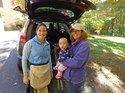
Catherine is ready hit the trail with Mommy & Grammy.
Just before we step off, I snap a photo and ask everybody to wave.

Catherine was awake for most of the hike.  So much to see!
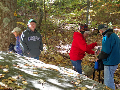
We take one of our many sight-seeing breaks while grabbing a snack.  Grandma has a ski-hat on, even though it's comfortable in the mid-50's.
Betsy said this log was at the prefect height for a seat.
Four generations on this hiking adventure.

A very pretty view, with just a splash of fall color amidst a sea of green.
From this outcropping on Crow Hill, you get a nice peek of Mt. Wachusett in the distance.
With about 3/4 of a mile to go, we find another seat-height log on the uphill path.
Dominic hiked almost the whole way, but need a little boost toward the end.
Here's our elevation profile.  The flat part was the picnic tables past Crow Hills. I had no idea that it climbed up that high again on the way to Redemption Rock.
 We made it to the car in 4:00 even covering a distance of 3.22 miles.  We ascended 767 vertical feet and came down 697 feet.  The downhill plunge after Crow Hills was by far the most challenging section.  The mountain laurel on the trail above the cliffs was particularly thick making the trail area pretty narrow.  However, I usually hike this section in the spring, compare here.

After finishing that, Tony & I went another 1.05 miles in 23 minutes and met the van at the base of Wachusett Mountain Ski Area.  That was a brisk walk at an average of 2.61 mph.

We didn't anticipate being out for 4 hours, but everybody survived and we enjoyed a beautiful fall day. 

Saturday, September 10, 2016

AMC Paddle: George's Island

This is something I've wanted to do for a long time:  paddle out to George's Island in Boston Harbor Islands National and State Park.  I've been out there several times taking the ferry boat from Long Wharf, but the idea of paddling out there under my own power just seemed like a really cool idea and a fun challenge.


Our put-in was at a beach on Morrissey Boulevard in Boston, just before the Dorchester gas tanks that you always hear about the the traffic reports for the Southeast Expressway.  Our AMC leader was very well prepared and even had printed maps for us of our planned route.  From Dorchester Bay, we were to travel easterly around the north tip Thompson Island to Spectacle Island.  After a short break there, we were to paddle around the north tip of Long Island, around Gallops Island, then beach at George's Island where we would break for lunch.  Then, it was more or less a straight shot back to our launch site, with a possible break at Chapel Rock in Squantum (Quincy).  This is considered a level 2 paddle requiring open water experience and a boat at least 14' long.

The beach at Dorchester Bay is all rocks.  We have to be careful with the boats, but at least its not mud.
Here's the landmark gas tank along the Southeast Expressway that will be our beacon back home.
Once out on the water, there was a terrific view of downtown Boston.
Our first stop was Spectacle Island.  This island is where all the dirt went when the build "The Big Dig", that is, the I-93 Central Artery / Third Harbor Tunnel Project through downtown Boston, the most expensive public works project in US history.  Everybody's tax dollars were at work here.  They built a very nice visitor's center here on the island as well as a small trail network.

On the beach in front of the visitors center.  If I look a little wet, that's because I just unceremoniously fell into the water trying to get out my kayak just before snapping this picture.
After some more paddling, avoiding the speeding ferries, we made it to George's Island.  The main attraction here is Fort Warren, a Civil War fort.  Interesting visitor activities are run here throughout the summer season.
The only rain we had on this trip was a couple minutes of spritzing during lunch.  Fortunately there was a nice big tent for shelter.  Underneath you can see my fellow paddlers:  Mike, Mike, Steph, Stephen, Nancy & Ed.
One can easily take a couple hours to explore the fort, especially if the kids are along.  I'm standing here on the edge of the parade ground on the interior.
The ramparts can easily be seen on the Goolgle Earth satellite view
Before we departed, we watched a long stream of sailboats past the island. 
One last look up the beach before we depart the island

All told, we paddled 13.58 miles in 6 hours.
No break was needed on the way back.  We had the wind and tide pushing us all the way to our starting point.  Just after passing by the south tip of Long Island, we had to cross a very busy channel. Until it was demolished in the spring of 2015, there used to be a bridge over the channel there from Moon Island and the mainland.  At one of the bridge supports that remained, we had to actually paddle backwards to stay out of the way of motor boats and many of the sailboats we saw earlier. Eventually, we crossed safely, paddling home into the late afternoon sun.  Total distance 13.5 miles.

Saturday, August 13, 2016

AMC Paddle: Three Lighthouses, RI

We have been so busy this summer that it's actually been a little hard getting out for a
paddling adventure.  But today I have a real good reason to get out:  I want to try out my new boat.  After my last paddle with AMC, I decided I shouldn't have to work so hard just to keep up.  I reasoned that better equipment (i.e. a new boat) should help improve my situation, and indeed it did.

The map at right gives a little perspective on today's paddle.  The objective of the route was to visit three lighthouses in the upper Narragansett Bay, just south of Providence.  The Wickford Paddle back in June was done much further south near the Jamestown Bridge.  As you can see, there is a lot to paddle in Narragansett Bay.

The forecast for the day was for temperatures in the mid-90's with possible afternoon thundershowers.  "Possible" became reality for us later in the day.

My new boat is a Current Designs Gulfstream designed by sea kayaking pioneer Derek Hutchinson.  It's 16'10" long, fiberglass, and only weighs 50 lbs (8 pounds lighter than my 15'6" Wilderness Systems Cape Horn).  Now that there are 4 boats in the "Fiedler Fleet", I think I've earned a promotion from Captain to Commodore.

My new Gulfstream.  I love the color, too.
The first lighthouse we paddle to is the Conimicut Lighthouse, south from our put-in and out in the middle of the bay.  The water was amazingly placid.
From there, it was a quick paddle to our second lighthouse at Nyatt Point.
After 2 hours of paddling, it was time for a lunch break.  The skies were still blue and the weather off the water was very hot and humid.  But I got to pose with my new boat.
At Haines Memorial State Park, we beached the kayaks and found some picnic tables in the shade.
There were seven of us paddling today:  Bill, Mike, Bill, Anne, Larry, Marie, and me.
Soon after we got into the water, this thunderstorm seemed to pop up out of nowhere. 
We pulled over at Sabin Point Park to keep an eye on the sky and make sure the storm passed us by.
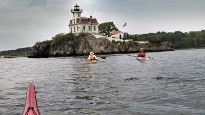
Back on the water, we finally made it to our third light house.  Pomham Rocks Light sits on an island, so we  circumnavigated it to see it all.
Weather clouds continued to threaten from the west, so after crossing the channel, we decided to make another stop at Save the Bay
We got off the water just in time.  You can see in this enlarged photo how hard the rain is coming down on the water.  We still got really wet, but far less so standing under the pier than if we were on the water.

Here's the summary for today's paddle. 
  • 3 lighthouses
  • 3 stops
  • 13.87 miles
  • 6:22 on the water
  • 4:36 paddling time
  • 3.0 mph average speed

Saturday, June 25, 2016

AMC Paddle: Wickford, RI

 Schedules have been particularly busy this spring, so squeezing in time for local adventure activities has been somewhat difficult. This AMC paddle was down in Wickford, Rhode Island, about 1:15 from home.  It was to be my first time out in my sea kayak this season, so I was really keen on making this trip.

The day started out perfect with a crystal clear blue sky, no mention of rain all day, with temps on the water around 80 and in the water about 65.

Wickford is actually a village in the town of North Kingstown Rhode Island, just south of Quonset Naval Air Station on Narragansett Bay.  Quonset is the where the famous Quonset Hut was first manufactured.  Nowadays, they have a really cool air show there every year in the spring.  Today's paddling party consists of 6 guys.  We put in from the beach near the Wilson Park fishing launch about 10:10am, winding our way through Wickford Harbor and out into open water.

Our first point of interest was circumnavigating Fox Island.  Since, it's privately owned, we couldn't land and explore here, but we did see the house and windmill.  Next, it was off to the Plum Beach Lighthouse, underneath the Jamestown Bridge.  Alex says he's seen this lighthouse plenty of times crossing the bridge on the way to visit friends in Jamestown or Newport.  Looking at the bridge from the exit of the harbor, I never thought we'd be able to paddle all the way down here, but we did.  My apologies for not getting any cool pictures here, but there was no way I was opening the hatch to take my camera out while paddling in open water.

After that, we started to make our way back to find a place to eat our lunch.  We stopped at Rome Point, part of the John H. Chafee Nature Preserve.  Harbor seals are known to stop over here on their migrations to and from Maine.  The views were beautiful.

We stopped right around high tide, so the boats were going to stay put.

This panorama shows the calm waters of the leeward cove.
On the bay side, the beach is rocky instead of sandy.
Here's the western section of the Jamestown bridge where we were just paddling.  You can just barely make out the lighthouse in front of the 5th "Y" pylon from the left.

From town, you can follow a sandy trail all the way out to the end of Rome Point .  The trail information makes it clear that it is "dog friendly" trail.
This is a shot of "the narrows", captured as I walked up the trail a bit.

Out toward Jamestown, some sailboats are taking advantage of the moderate breezes and clear blue skies.
  After a nice lunch, we worked our way along the shoreline back into the harbor (still some significant paddling to do).  When we made it back, I found that we had traveled 12.1 miles with a total paddling time of 3:35.  We didn't really take any breaks so I was sore on Sunday, but it was worth it.